The first time I showed the app to someone who had never used it, I had to gently extract my phone from the person’s hand. This happened the second time, too, and was followed by an email requesting the name of “that mapping program.”
The app is called OnX. Its basic functionality is simple: OnX shows you where you are in real time, using a blue dot exactly the same as the one on Google Maps. The difference is that OnX is designed to show where you are in a forest, on a mountain or in a canyon. It has been around since 2009 and is popular with hunters and outdoor enthusiasts.
It is also at the root of a potentially far-reaching case in federal court in which a Wyoming landowner accuses four hunters of trespassing — and causing millions of dollars in damage — even though they never stepped foot on his land.
OnX was born when Eric Siegfried, a mechanical engineer and part-time hunting guide in Montana, decided to make a Google Maps for the wilderness. He had solid navigation skills, he said, but was sick of getting lost.
To address the problem, he filled up a workspace in his wife’s scrapbooking room in Missoula with U.S. government maps, which he then loaded onto a microchip. OnX’s layers of data would eventually include everything from wind patterns to fire histories. The most important data by far, however, showed property lines. (...)
Property data is often inaccurate and outdated, and early in the development of OnX Mr. Siegfried found himself asking, “Why is there no nationwide picture of land ownership, of public and private property boundaries, of who owns what?”
This was the “game changer,” he has said. By collating state and county data and putting it on a microchip, Mr. Siegfried turned the project in the scrapbooking room into a company that just received more than $87 million from investors and that understands the American landscape arguably better than the government does.
It turned OnX almost overnight into a popular tool for the nation’s 15 million hunters.
In answering the question of who owns what, OnX helped bring to light how much public land — often highly coveted — is not reachable by the public. That’s because private landowners control access.
Across America, 15 million acres of state and federal land lies surrounded by private land, with no legal entry by road or trail. Most can be found scattered across the West, moated by ranches and corporate holdings. Such “landlocked land,” if it were one contiguous piece, would form the largest national park in the country, an area nearly the size of Vermont, New Hampshire and Connecticut. (...)
Throughout the West, hand-held technology has added a volatile ingredient to an already simmering conflict between landowners and outdoor recreationists. In small town after small town, the increased visibility of property lines on devices has coincided with a generational shift in land ownership, as wealthy out-of-state buyers have scooped up vast portions of countryside.
Many of the new owners, after buying old ranches where hunting access was generally permissive, have converted them into tightly controlled private hunting experiences charging upward of ten thousand dollars for a single elk. (...)
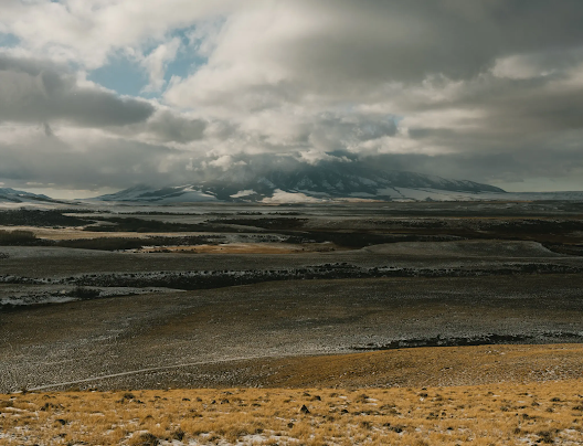
Using OnX’s 3-D view, hunters can zoom in on the mountain’s rugged, varied terrain, which provides abundant refuge for pronghorn antelope, black bear and mule deer. They might even pinpoint the ledge where they intend to perch on Opening Day, waiting for one of the mountain’s 2,000-pound bull elk to pass by.
More important than its game-friendly topography, however, what Elk Mountain offers is landlocked land — and a legal loophole of sorts, offering access for a hunter willing to take risks.
Most of the nearby area is owned by Fred Eshelman, a drug company founder from North Carolina. In 2005, Mr. Eshelman bought a 50-square-mile ranch encompassing much of the mountain and multiple trout-filled lakes. His large home is visible for miles. And as he settled in, he aggressively moved to ward off hunters. (Not because he opposes hunting. Mr. Eshelman is a mountain lion hunter.)
However, he couldn’t keep the public out, for interspersed within his property lay 27 parcels — 11,000 acres in total, an area the size of several airports — owned by the federal Bureau of Land Management and the State of Wyoming.
Hunters tend to steer clear. “If you cross, they call the sheriff,” reported one poster on Hunt Talk, a message board. Wyoming has multiple laws against trespassing. And “if you were looking for a red-as-red county where people are pro property rights,” said Sabrina King, a lobbyist for the Wyoming chapter of Backcountry Hunters and Anglers, Carbon County, home of Elk Mountain, “would be it.”
Some hunters have long believed, however, that the publicly owned parcels on Elk Mountain can be legally reached using a practice called corner-crossing.
Corner-crossing can be visualized in terms of a checkerboard. Ever since the Westward Expansion, much of the Western United States has been divided into alternating squares of public and private land. Corner-crossers, like checker pieces, literally step from one public square to another in diagonal fashion, avoiding trespassing charges. The practice is neither legal nor illegal. Most states discourage it, but none ban it.
by Ben Ryder Howe, NY Times | Read more:
Image: Elk Mtn. Wyoming/ James Stukenberg for The New York Times